Amherst Village Historic District
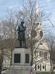
Historic district in New Hampshire, United StatesThe Amherst Village Historic District encompasses the historic village center of Amherst, New Hampshire. Centered on the town's common, which was established about 1755, Amherst Village is one of the best examples of a late-18th to early-19th century New England village center. It is roughly bounded on the north by Foundry Street and on the south by Amherst Street, although it extends along some roads beyond both. The western boundary is roughly Davis Lane, the eastern is Mack Hill Road, Old Manchester Road, and Court House Road. The district includes the Congregational Church, built c. 1771-74, and is predominantly residential, with a large number of Georgian, Federal, and Greek Revival houses. Other notable non-residential buildings include the Farmer's Bank, a Federal-style brick building built in 1806, and the Amherst Brick School, a brick Greek Revival structure that has served as the School Administrative Unit 39 offices since 1997.
Read article


Top Questions
AI generatedMore questions
Nearby Places
Amherst, New Hampshire
Town in New Hampshire, United States

Milford (CDP), New Hampshire
Census-designated place in New Hampshire, United States

Milford, New Hampshire
Town in New Hampshire, United States

Amherst (CDP), New Hampshire
Census-designated place in New Hampshire, United States

Milford Cotton and Woolen Manufacturing Company
United States historic place

Milford Town House and Library Annex
United States historic place

William Peabody House
Historic house in New Hampshire, United States

Milford Suspension Bridge
United States historic place